
Airborne Validation Unified Experiment Land to Ocean (AVUELO)

Overview
AVUELO (Airborne Validation Unified Experiment: Land to Ocean) is a NASA-led project that aims to enhance understanding of biodiversity in tropical ecosystems. It includes airborne hyperspectral and radar data collection as well as field measurements. AVUELO is led and supported by NASA and the Smithsonian Tropical Research Institute (STRI) in Panama, with additional major contributions from other scientists and institutions.
The 2025 hyperspectral campaign
The 2025 AVUELO campaign focused on advancing the validation and calibration of spaceborne imaging spectroscopy (hyperspectral) data for tropical ecosystems by combining airborne imaging spectroscopy for terrestrial and marine sites in Panama and Costa Rica with contemporaneous field measurements and data collected in February 2025.
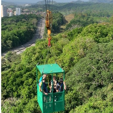
NASA’s Airborne Visible-Infrared Imaging Spectrometer 3 (AVIRIS-3) was deployed on a King Air aircraft to collect hyperspectral imagery between February 6 and February 28, 2025. Terrestrial collections in Panama encompassed many intensively studied sites having a wide variation in soil type, geology, rainfall, and vegetation type. These included managed landscapes, secondary forests of varying ages, and old-growth forests in lowland, montane, and coastal habitats (e.g. mangroves). All areas were collected at 3 m spatial resolution, with intensively studied focal areas of particular interest collected at 1 m resolution. In Costa Rica, AVUELO focused on Rincon de la Vieja volcano to assess differences in vegetation growth due to natural CO2 enhancements. It also collected data over coastal waters off the Pacific to support calibration and validation of PACE, which is a hyperspectral satellite sensor focused partly on oceanic observations.
Associated terrestrial field work focused on acquiring data on the traits and taxonomic identity of canopy plant species captured in the airborne imagery. An intensive program of canopy leaf collections took place close in time to the 2025 overflights. Over 900 samples of over 400 plant species were collected in central Panama. Reflectance spectra were measured on the collected samples, which were all identified to species by expert botanists. Currently leaf functional trait measurements are underway. Associated field work includes mapping crowns over >150 ha of mapped forest plots with high spatial precision, to enable linkage of pixels in the airborne data to species identity of canopy trees and lianas.
The 2026 radar campaign
The 2026 AVUELO campaign focuses on advancing the validation and calibration of spaceborne vegetation data for tropical ecosystems by combining airborne synthetic aperture radar (SAR) data collection in Panama in May 2026 with field measurements of vegetation water content and forest structure.
As part of the campaign, AVUELO will use UAVSAR, NASA’s airborne radar sensor, which can see through clouds and provide detailed information about the structure and condition of ecosystems, from forest canopies to coastal wetlands such as mangroves. These detailed airborne observations, combined with measurements collected on the ground, provide a more complete picture of vegetation and its biodiversity. The tools, datasets, and maps developed from this work are then used to develop and refine algorithms for satellite data analysis (such as NASA’s recently launched NISAR mission), improving our ability to monitor ecosystems in tropical regions worldwide and understand how these environments are changing.
The field component builds on extensive existing datasets from STRI forest sites, including forest plot inventories as well as airborne and terrestrial lidar data. In addition, field teams will collect vegetation water content profiles throughout the canopy at the Parque Metropolitano crane site, timed to coincide with UAVSAR overflights. Mangrove forest structural measurements will also be collected to address a key data gap.
Synergies
An important aspect of AVUELO is the synergy between 2026 UAVSAR (radar) data and 2025 AVIRIS (optical) observations. UAVSAR data will be collected over many of the same areas previously surveyed with AVIRIS, enabling the integration of forest structural information with insights into ecosystem function. While UAVSAR characterizes forest structure (e.g., biomass, vertical layering) and vegetation water content, AVIRIS provides information on plant traits such as leaf chemistry, photosynthetic activity, and overall plant condition. Together, these datasets provide a more comprehensive characterization of forests, offering new insights into the distribution of biodiversity and helping researchers understand where different types of vegetation are found, how healthy they are, and how they contribute to storing carbon, cycling water, and supporting ecosystems.
Stats – 2025 terrestrial airborne campaign in Panama:
- Estimated total of 64 flight hours and approximately 20 terabytes of AVIRIS data collected.
- Acquired 3-meter airborne imagery over Smithsonian sites near the Panama Canal in early, mid and late February.
- Acquired 1-meter imagery on a single date for intensively studied focal sites in Panama: Barro Colorado Island, Agua Salud, Parque Metropolitano canopy crane, San Lorenzo canopy crane, Parque Summit, and the Gigante fertilization experiment.
- Acquired one-time 3-m imagery data over additional sites of interests, including mangroves (blue carbon sites), montane forests, reforestation areas, agricultural sites, a world heritage site (Coiba Island), and more.
- Acquired repeat airborne data over methane sources, including Gatun Lake and a large landfill near Panama City.
Stats – 2025 terrestrial ground campaign in Panama:
- Completed 28 days of in situ terrestrial collections.
- Collected 941 plant samples from 457+ species—including 76+ species of lianas—across 304 genera and 95 families.
- Measured reflectance spectral measurements of all canopy leaves, and absorbance spectra of a subset of leaves.
- Canopy leaf traits: Leaf water content and leaf mass per area (LMA) measured on fresh leaves of all samples. Measurements of leaf shape and venation and stomatal characteristics are in progress on the collected material or scans. Planned leaf chemical analyses include elemental composition, pigments, and carbohydrates.
- Tree censuses: Recensused 58 ha of large forest plots for trees > 20 cm dbh on Barro Colorado Island. https://datadryad.org/dataset/doi:10.5061/dryad.1g1jwsvc3 (lead by Joe Wright)
- Crown mapping: Mapped crowns in over 150 ha of mapped forest plots, thereby assigning tree species identities and determining liana cover for each crown. (lead by Fernando Arauz)
- Plant DNA barcodes: Obtained DNA barcodes for 150 plant tax. (lead by Kristin Saltonstall)
- Plant genome sizes: Measured genome size with flow cytometery for 400 Panama plant species.
Stats – 2025 marine campaign in Panama and Costa Rica
- Acquired data over coastal areas in support of PACE cal/val.
- Completed 4 days of coastal collections.
- Collected phytoplankton net samples and niskin bottle samples (HPLC, chlorophyll, CDOM, nutrients, bacteria) across 23 stations.
- Spectral measurements continuously gathered along boat transects.
Project Leads

Erika Podest,
PhD
AVUELO
Project scientist

David Schimel,
PhD
AVUELO
PI

Kelly Luis,
PhD
AVUELO Coastal Component Lead

Helene C. Muller-Landau, PhD
AVUELO STRI
Lead

Phillip Townsend,
PhD
AVUELO
Co-Lead

Shawn P. Serbin,
PhD
AVUELO
Co-Lead